The Villages
Before the development of the housing scheme in the 1950s, life in Greater Easterhouse was very different than it is there today.
The area had a cluster of small villages populated by the people who worked in the local industries of farming, mining, weaving and the canals.
In Timothy Pont's map and manuscript of 1596 the area where the late 19th century village of Easterhouse later developed was called 'Conflat'. The term conflat derived from corn/wheat flats - flat land where wheat was farmed.The William Forrest map of 1816[ calls the area of the old village Wamnat.
The village of Easterhouse was built from the late 19th century in land owned by, and south of, a farm of that name, in the immediate area around where Easterhouse railway station stands. The village was bounded to the north by the Monkland Canal and to the south, almost continuously with, the village of Swinton. The villagers worked in a number of industries including the canal, the stone quarry at Auchinlea, coal mines at Gartloch and Baillieston but mainly in the surrounding farms and estates as agricultural worker
Easterhouse village, known to locals as the Holy Land, was a mining village, with small cottages on either side of the street. Easterhouse Road was the heart of the village, with general stores and a bar, and even a piggery where Rogerfield now stands.

The village was a favourite place for childrens outings. The Co-op ran an annual trip for children from the South-side of Glasgow. They came in horse-drawn carts as far as Riddrie, and then a horse-drawn barge took them up the canal to Easterhouse for a picnic.
Sunday School children from Coatbridge arrived on hay wagons to play games and races in the fields surrounding the village. In winter, local people went curling and skating on Bishop Loch.

Swinton Cross
Swinton and West Maryston had a couple of shops, some run from dwelling houses. There was a pump in the middle of a field where people got their spring water. There were no wash houses, and people had to boil their clothes in a big iron pot on a brick fire to clean them.

West Maryston from the Canal
When rebuilding of the area started in the inter-war years, the authorities decided to run-down Easterhouse village. At this time, street lighting was being introduced and roads which didnt get this were effectively condemned
Easterhouse from canal
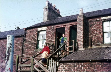
I wondered whether you would like to see this picture of my Grandmother-in- law’s home in a tenement on Easterhouse Road, Easterhouse, taken in 1966. One of Grandma’s sons lived in Whamflet Avenue, then an unmade-up road near the canal. The family name was Hannah. Aunt Sarah lived in adjacent tenements, made up of a room and kitchen. Grandma brought up her sons, all four of them, here, after their father, a miner died of TB at an early age. The chimney in the foreground belonged to the shared wash house.
Valerie Hannah Conwy Wales

Carpet Beater
100 years ago, people living in the villages had none of the modern appliances that make life easier for us today. There were no vacuum cleaners- people had to take their rugs outside and use a carpet beater to thrash out the dust!

Iron
No one got creases out of their Sunday-best clothes using electric irons. Instead they used flat irons, heated over the fire or filled with hot coals to warm them.
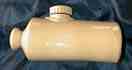
Stone Pigg
Imagine how cold it would have been in winter with no central heating! People warmed their beds with a brick from the hearth, or used stone pigs like this one, filled with hot water like the rubber bottles we use today.
Local Industry
There are few districts which combine so much of the attributes of country life with the bustle and stir of manufacturers; for the soil is dotted at every little distance with the villas of the aristocracy of Glasgow; with tall chimneys of coal works, with belts of thriving plantations and clumps of old wood, with orchards, grassy holms, or waving grain, and with the homely farm steading or lonely dwelling of the cotter Ordinance Gazeteer of Scotland 1884.
Farming
Much of Greater Easterhouse is built on old farmland. Several farms were either partially or completely taken over by the housing schemes that were built in the 1950s. All that remains of most of them are their names, which were given to the new streets. You might still find clumps of trees which surrounded the farm houses today.
Farms on old maps include Easterhouse, Westerhouse, Nether House, Dungeonhill, Rogerfield, Greenwells, Commonhead, Wellhouse, Queenslie, Blackfriars, Provanhall, Lochwood and Lochgreen.
There was a farm in the grounds of Gartloch Hospital, as it was believed mental patients benefited from the theraputic effects of working there. It provided milk, butter, oatmeal, eggs and meat form its own abattoir to the hospital, and also later to the Royal Infirmary, the Southern General, and Barlinnie and Low Moss prisons.
Over 100 years ago the best farms had a four-year crop rotation. One year the farmer would grow potatoes, the next turnips, the next oats and then the last, wheat. Then the cycle would begin all over again.
Many of the farms owned livestock such as cattle or poultry. Imagine how the farmers must have felt watching the new housing estates creeping closer to their land? One poor man in the 1960s had 100 of his hens stolen. They were found with their heads chopped off in a field the next day.
Amid the modern houses, there are still people farming the land in Greater Easterhouse today.
Coal Mining
Coal has been mined in Easterhouse for hundreds of years. The monks of Newbattle Abbey were given much of the land in what is now Greater Easterhouse in the 12th Century by King Malcom IV. They were amongst the earliest coal miners in Scotland.
250 years ago, coal cropped out, or became exposed here. It was because the coal seams were so close to the surface that the district was one of the first to mine coal in Scotland. At that time, miners would have worked in cramped conditions in Bell Pits.
Coal Mining became a major local industry in 1790 with the opening of the Monkland Canal. It could then be sent to Glasgow, rather than just catering for local needs. Old maps show around 30 pits around Ballieston at that time. Coal was also mined at Dungeonhill, Provanhall and Bishop Loch. The industry brought a new population to the district, many coming from Ireland to work in the pits.
Working conditions were very poor for the coal miners working in Greater Easterhouses pits. Many of the mines were difficult to work and were vulnerable to dangerous flooding. Wages were low and families survived on very basic staples as soup, potatoes, sour milk, bread and porridge.
Before the introduction of motorised pulley systems, pit ponies pulled the heavy coal trucks through the mines. Many would live down the pit for fifty weeks of the year, never seeing daylight.
Weaving
Over two hundred years ago flax was grown in the area for linen making. Some farms grew 20-30 acres of the crop a year. Swinton, West Maryston and Ballieston were thriving weaving villages.
At Wellhouse Farm, strips of linen were laid out to bleach under the sun in the fields. The weavers would then carry the heavy rolls of linen on their shoulders to Glasgow.
Flax growing died out around 150 years ago, when cotton became more common.
The Monkland Canal
In 1769 magistrates in Glasgow had to find a way to transport coal to the city from the East. They decided to build a waterway. They allocated the job to James Watt who invented the Steam Engine. Ten miles were constructed when the company found itself in difficulty financially and it sold out to William Stirling & Son who owned Drumpeller Estate. They completed the waterway in 1790.
Barges carrying coal and steel were running daily into the city. Its profits grew after 1825 when the great iron works at Calder, Gartsherrie, Dundyvan and Langloan were built.
The Monkland Canal became known as The Killer Canal. Many people drowned there through the years. This Certificate of Bravery was awarded to for his rescue of a child who had fallen in the water in
In May 1964 work began filling in the canal at a cost of 300,000. The canal is now part of the M8 motorway which opened on June 1973.
In 1807 passengers were ferried along the canal in boats drawn by horses. For over 160 years barges used the canal. It was closed to shipping in 1952.
The Dairy Farms
Children were sent from the villages to the local farms to collect milk. If you had lived in Easterhouse village, the soor milk cairt would have delivered butter to you twice a week from Dungeonhill Farm.
Weaving Shuttles
These are shuttles, which were traditionally used in cloth weaving. Old accounts tell how many local people as children had watched the weavers at work, fascinated by the clickety clack of the shuttles
Trondra Local History Project
The Trondra Local History Group came together in 2000, where they began a local investigations module at John Wheatley College. They approached the Open Museum, and suggested working on an exhibition about their local community.
The resulting exhibition Hidden History, Greater Easterhouse More Than Just a Scheme tells the story of Greater Easterhouse from its earliest origins, 9000 years ago, to the rapidly changing face of the area and features local history of the area, the history of Provanhall, its royal connections and ghostly residents.